Your mission: to find a map showing the landscape of your college region prior to European arrival. This will be a somewhat tricky endeavor, although there is a good chance to you will stumble across a map in a book on pre-contact history, a historical atlas, or in a local museum.
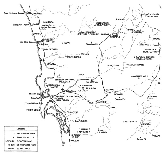
Above, the example is Richard Carrico’s map of San Diego around 1775 when the Kumeyaay participated in an uprising. He published this in Journal of San Diego History, Vol. 43, No. 3, 1997 in an article entitled, “Sociopolitical Aspects of the 1775 Revolt at Mission San Diego de Alcala.” This isn’t quite pre-contact, since the Spanish arrived in 1769, but it’s very close.
I learned of Richard’s work (his bio) by talking to John Johnson, who draws similar maps for the Chumash culture area from his spot at the Santa Barbara Museum of Natural History. Something that immediately struck me about the Kumeyaay landscape is how unimportant is the port of San Diego, in contrast to the modern focus. The big focus is on the rivers, around which are clustered the native villages. Richard told me that the word “Ja” means water in Kumeyaay and there are many towns that start with “Ja” such as “Jamacha.” Each of those places was important in this extremely dry landscape due to the water sourced there.
DUE: Nov 7