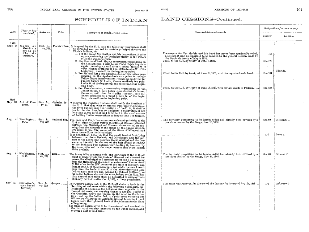
Image of the original wording of the treaties. "Schedule of Indian Land Cessions - Continued." A Century of Lawmaking for a New Nation: U.S. Congressional Documents and Debates, 1774 - 1875 U.S. Serial Set, Number 4015, 56th Congress, 1st Session, Pages 706 and 707. The Library of Congress, American Memory. https://memory.loc.gov/cgi-bin/ampage?collId=llss&fileName=4000/4015/llss4015.db&recNum=158&itemLink=D?hlaw:1:./temp/~ammem_ojQn::.
Excerpt from above. "Schedule of Indian Land Cessions - Continued." A Century of Lawmaking for a New Nation: U.S. Congressional Documents and Debates, 1774 - 1875 U.S. Serial Set, Number 4015, 56th Congress, 1st Session, Pages 706 and 707. The Library of Congress, American Memory. https://memory.loc.gov/cgi-bin/ampage?collId=llss&fileName=4000/4015/llss4015.db&recNum=158&itemLink=D?hlaw:1:./temp/~ammem_ojQn::.
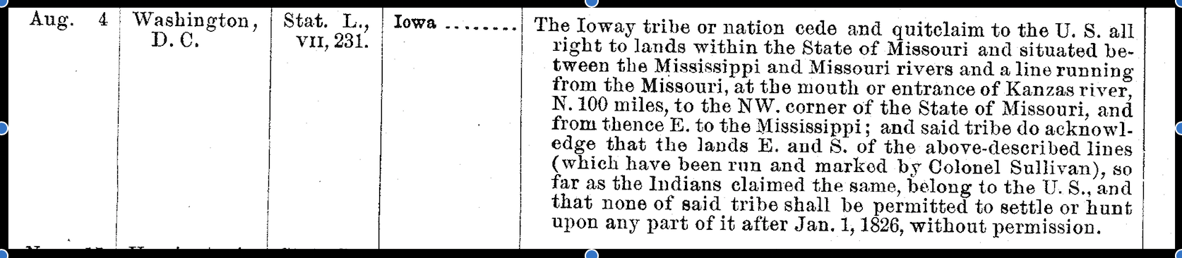
The Treaty of 1824 was signed on August 4, 1824 in the city of Washington. This treaty was the first that took land from the Ioway tribe and included the entire northern half of the state except for the Platte Purchase which would later be taken from the Ioway and Sac and the Fox tribe in the Treaty of 1836. By order of this treaty, the Ioways were required to move out of the area by January 1, 1826. In return for the sale of the land, the United States was to pay five hundred dollars, annually, for the term of ten succeeding years and provide the support of a blacksmith as well as furnishing the tribe with farming materials, cattle, and people to help with the tribe’s agriculture until the President of the United States says that this will no longer be required whether due to expense on the US or other reasons. The treaty was signed by two Ioway chiefs, Mahoskah (White Cloud) and Moanahonga (Great Walker/Big Neck) and the Superintendent of Indian Affairs, William Clark. Moanahonga did not understand the terms of the treaty and stayed in the territory which later caused a dispute with incoming settlers in 1829 in the Chariton Valley Area which is referred to as “The Big Neck War”.
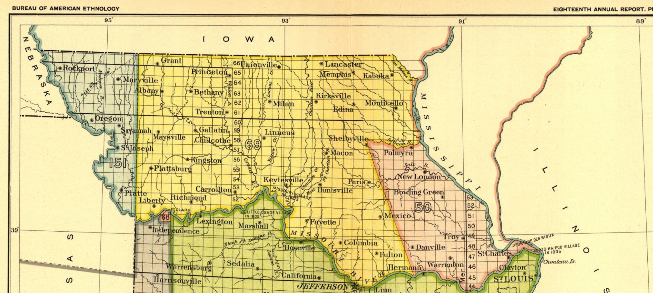
The yellow section on the map below is the land ceded in this treaty.
Royce, Charles C. and Thomas Cyrus. "Missouri 1." 1899, Indian Land Sessions in the United States. Library of Congress Geography and Map Division Washington, D.C., https://www.loc.gov/resource/g3701em.gct00002/?sp=37&r=-0.474,-0.03,1.969,0.861,0.
Treaty of 1830
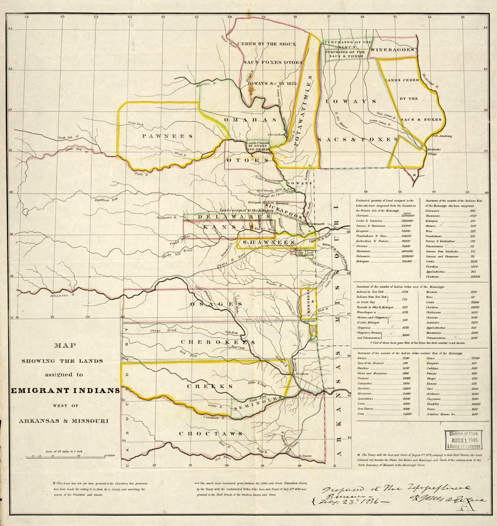
United States. Topographical Bureau. "Map Showing the Lands Assigned to Emigrant Indians West of Arkansas and Missouri." 1836, Library of Congress, https://www.loc.gov/item/99446197/.
The second treaty to be signed at Prairie du Chien. This particular treaty was made due to warring among the Sacs, Foxes, Sioux, Iowa, Omaha, and Otoe involving the hunting grounds located in western Iowa, Missouri, and Minnesota. This treaty did not have an interpreter present and the Ioway were unaware that they had given up the lands involved in the treaty. Due to this they ceded lands in Western Iowa and Missouri. No white settlers were allowed in the ceded lands and a coerced peace was established.
The map above was created by the Topographical Bureau to show where Native American tribes were placed due to the Indian Removal Act of which was signed on May 28th, 1830. This would be the placement of the tribes before the Treaty of 1830 as that treaty was signed on July 15th, 1830.
To read this treaty in full. Follow this link below.
United States Census Bureau. "Americanindiansmapcensusbureau." 2006, Wikimedia Commons, https://commons.wikimedia.org/wiki/File:Americanindiansmapcensusbureau.gif. [Image has been cropped].
These treaties deal with the movement of the tribes to reservation areas and the last treaty to be made with the Ioway tribe.
Treaty of 1836
The treaty of 1836 is also known as “The Platte Purchase.” The treaty was made because white settlers came onto the Ioway and Sac and Fox lands illegally and the tribes were pressured to relinquish their lands in Missouri. In return, they would receive lands in present day Kansas/Nebraska.
Treaty of 1854
The tribes, with their new reservation in Kansas, which was promised to be theirs forever, were faced with continued corruption during this period of time. This treaty allowed for railroads and roads to be built on their lands and the Ioway themselves lost most of the reservation given to them from the treaty of 1836.
Treaty of 1861
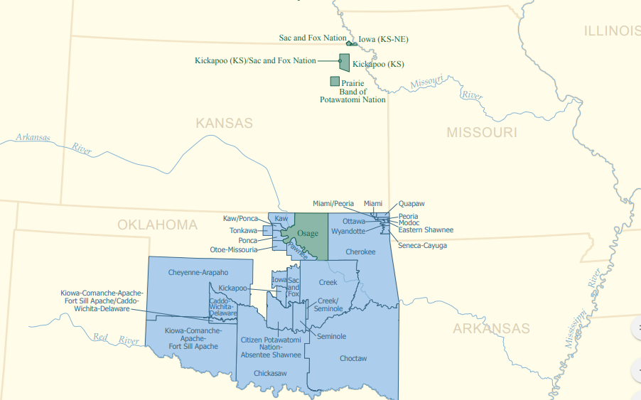
This is the last Ioway treaty. It involved the Sac and the Fox tribe and the Ioway. Both tribes ceded lands, and the lands they received in return are the current land arrangement seen with these tribes. The current arrangement can be seen on the map above.
To learn more about the treaties made between tribes in Missouri follow the link to the right.