Reflection Blog

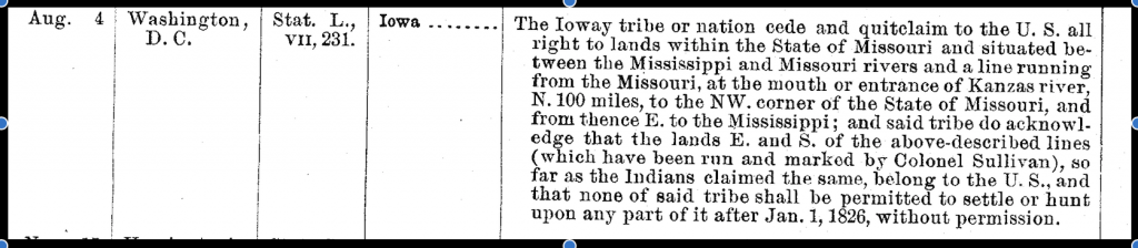
This semester has definitely been a learning experience for me, from the content that I learned about our course material to the knowledge necessary for creating a digital site. The semester began with an introduction to the course material, and we were immediately introduced to WordPress, the platform through which we would be creating this website. I found the early introduction to the format to be immensely helpful, but there were some areas that I think could have been made clearer/improved upon. Since the final website was made using pages, and not posts, I would have liked to have been encouraged to make my weekly assignments in post form. I believe that this would have helped me better translate the research that I did into the necessary format for a website. Additionally, we were given access to our personal blogs early on in the semester, but we were not told to start combining our work with our partner until much later. While I understand the need for autonomy when grading each individual, I feel like our project would have benefited from a more closely aligned partnership. If we were instructed to begin formatting content with our partner at the beginning of the course, we would not have had to spend as much time rewording our materials so that there is a consistent format on our website. Overall, I think creating websites is a really good way to distribute the information that we learned during the class, and I was able to learn to use technology with which I previously had no experience.

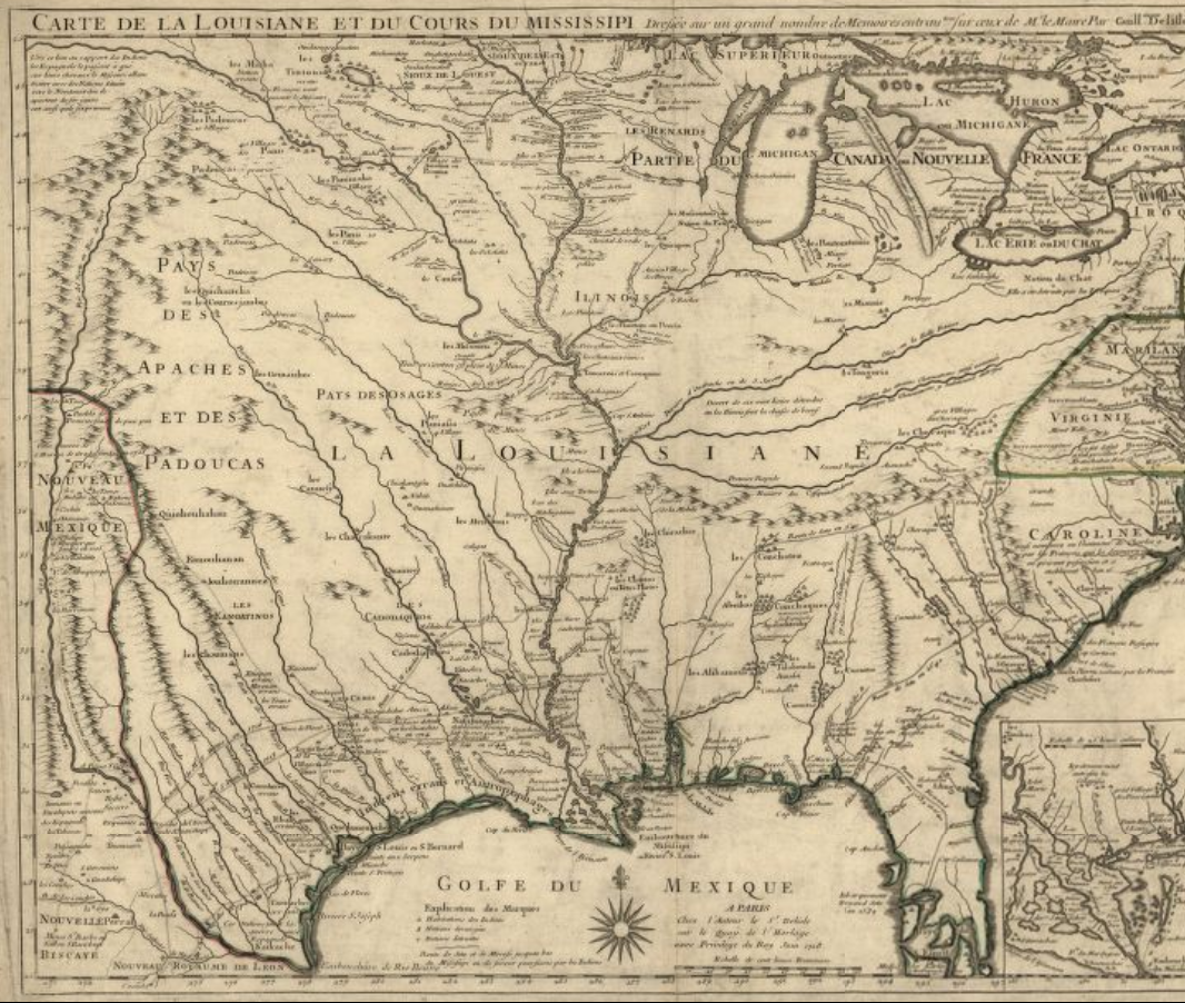
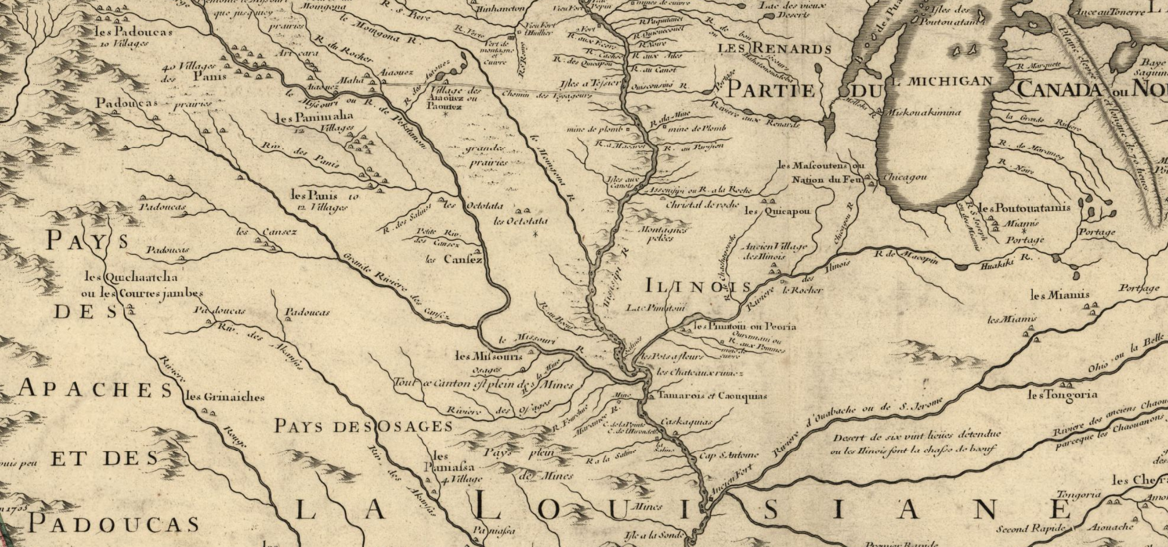
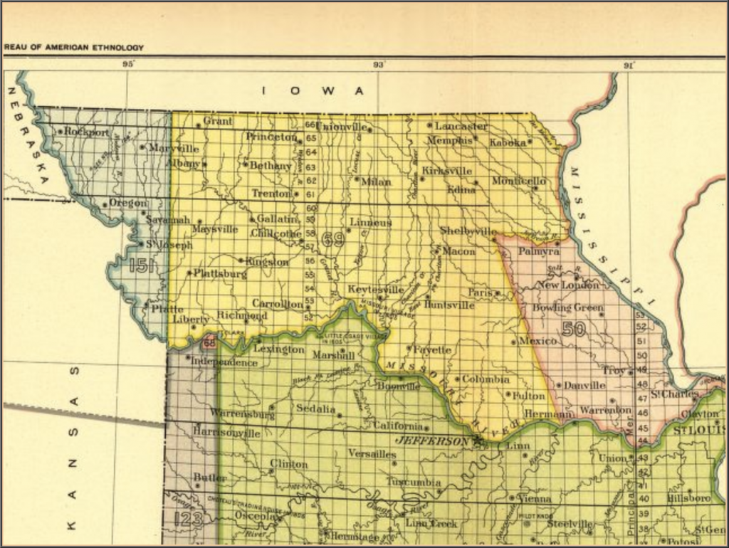
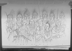
In terms of the project that I, and my partner completed, I believe that we fulfilled our expectations. We created a project contract that laid out each item we wanted to see on our website, and while one or two items did not make it from the contract into the site, we determined that they did not fit. Once we began creating our pages, we realized that our narrative had changed slightly from the original project contract. I feel like this is the nature or a website project though. It was not until we could see the content on the pages that we really knew whether or not something would work. And even though some individual items from the project contract did not make it on, the major portions were present. We explained the purpose of our site on the homepage and tried to introduce the reader to our location, specifically as a native space, by using a map with the rivers that were important to the Ioway, Missouria, and Otoe tribes. We also introduced the three main tribes from our area as well as places that still have a native presence. Once we had introduced the people who this land was taken from, we explained the extensive process of dispossession that happened to remove the Ioway, Missouria, and Otoe from their lands. Our website explains how this dispossession started with the French and culminated in the early to mid 1800s with the United States government and the many treaties that were signed. Additionally, we wanted to ensure that our readers realized that just because the Ioway, Missouria, and Otoe do not currently live in Missouri, they are making efforts to regain their land and heritage. This was specifically done through emphasizing their current efforts. The Ioway, Missouria, and Otoe’s stories are not over, they are still a presence here in the United States, and hopefully this site will help introduce people from the Kirksville and Northeastern Missouri area to these three tribes.

“Legal Dispute” – Challenging Narratives of Erasure

Corruption at Effigy Mounds

Effigy Mounds is located in Northeast Iowa and is home to multiple Plains Tribes burial grounds. This area has long been considered a “‘sacred place where Nations meet'” (Blake) by many Native American tribes, but in 1990 tragedy struck. The caretakers appointed by the United States government stole over 40 sets of remains from the Mounds and National Monument Museum. These bone were put in garbage bags and left in someone’s garage to sit for almost thirty years.In 2011, this corruption/evil act was discovered and an investigation was launched to prove that the bones were stolen and to return them to their rightful home. Finally, in 2016 guilty members parties were sentenced.

Lance Foster, the Tribal Historic Preservation Officer for the Iowa Tribe of Kansas and Nebrask said, “They’re secure. Plans are being made to repatriate them and the tribes are going to be part of that process. It will be done as soon as we can get everything figured out, to put them back here somewhere.” The many tribes, whose ancestors are buried at Effigy Mounds, will work together and come to a consensus about the reburial of their Tribal Ancestors as a group.

If you want to read more about the incident, the link below will take you to the news article about the story.

Returned to their journey: Bones of 41 American Indians removed from Effigy Mounds returned to their tribes for reburial

As a side note/slight digression from this story, I think that it would be interesting to interview Native American tribe members to hear their thoughts on sacred Native places being used as National Monuments/tourist attractions.

The Pre-contact Landscape

European contact in the area that is today know as Missouri began in the late 1600s when French explorers traveled along the Mississippi River. One of the earliest maps of this area was created in 1718 by Guillaume de L’lsle, and his map actually shows much of United States with a large emphasis on the rivers and waterways.

Image from the Library of Congress Geography and Map Division, Washington Control Number: 2001624908

A more close-up look of the Northern Missouri area shows how the land of the Ioway was between three major rivers.

Excerpt from previous image.

In comparison, a map from today shows that there are two more rivers/waterways intersecting the area north of the Missouri River than were shown on the map from 1718.

Wikimedia Commons: Mississippiriver-new-01.png

While the first two maps do not predate European contact, they seems to focus more on the land as it’s own property, and not as something to be owned by people which is similar to the views of the Ioway, and most Native American tribes. In contrast, many of the other maps that I found focused on the 1800s when U.S. settlers were moving into the area and claiming land. The maps were divided by artificial lines marking ownership and counties.

Links to Pictures:

https://www.loc.gov/resource/g3700.ct000666/?r=0.448,0.246,0.372,0.329,0

https://commons.wikimedia.org/wiki/File:Mississippiriver-new-01.png

The Treaty of August 4, 1824

On August 4 in the year 1824, the Ioway tribe signed a treaty with the U.S. government ceding much of their land in the state of Missouri. The treaty itself is relatively short, taking up only a few lines, but it gave up large portions of Ioway territory. It was signed in Washington D.C. by two Ioway Chiefs, White Cloud and Great Walker (Big Neck). These two chiefs represented different portions of the Ioway tribe, and as evidenced by the Big Neck Affair there was some controversy related to it’s signing.

This first document, “Schedule of Indian Land Cessions-Continued,” shows that the treaty signed by the Ioway is only one of many treaties that Indian nations signed during this period.

https://memory.loc.gov/cgi-bin/ampage?collId=llss&fileName=4000/4015/llss4015.db&recNum=158&itemLink=D?hlaw:1:./temp/~ammem_ojQn::

The second document is a screenshot of the exact wording for the 1824 treaty between the Ioway and the United States government.

https://memory.loc.gov/cgi-bin/ampage?collId=llss&fileName=4000/4015/llss4015.db&recNum=158&itemLink=D?hlaw:1:./temp/~ammem_ojQn::

Finally, the third image shows the land that the Ioways ceded in Northern Missouri in the 1824 treaty. Adair County and Kirksville, which is the primary land area this project is focusing on, are in this cession. The yellow portion of the map below, with the number 69 on it, shows the ceded land.

https://memory.loc.gov/cgi-bin/map_item.pl

Sources:

Library of Congress – American Memory

A Century of Lawmaking for a New Nation: U.S. Congressional Documents and Debates, 1774-1875

U.S. Serial Set, Number 4015, 56th Congress, 1st Session, Pages 706-707

Indian Land Cessions in the United States, 1784 to 1894

Baxoje, the Ioway Nation – nativeweb.org

Ioway Cultural Institute: History

Treaties Page


Native Origins Narrative

The Ioway, Missouria, and Otoe tribes are descended from the Winnebago. The Winnebago are from the Northern United States, particularly the Great Lakes area. Many of the origin tales for this overarching tribe say that they worked their way down from the North, and as they traveled they ran into food shortages. When the shortage was particularly bad, certain groups within the larger tribe would split off and travel to a new area. This is what happened with the Ioway, Missouria, and Otoe. They left the Winnebago and the Great Lakes region and settled throughout current day Iowa, Missouri, and Illinois.

These three current day tribes had similar origins and subsequently similar origin tales. The tribes are said to be made up of clans such as the Bear, Beaver, Elk, Eagle (Thunderbird), Buffalo, Pigeon, and Owl. One of the websites that I looked at said that the Bear Clan is mostly made up of descendants of the Whitecloud family. Since many of the Ioway stories and artifacts that I have seen mention a Chief White Cloud, it is possible that the Ioway from our area are part of the Bear Clan. Additionally, it seems that most of the Whitecloud family settled in the Kansas Nebraska tribal lands.

There are many origin narratives for the Bear Clan with 12 different ones listed on one site. One of the most consistent parts of the tales is that the Bear Clan members actually started out as bears and were transformed into humans. They were/are also the soldiers of their people; they protected them and were policed the other tribes. Additionally, the Bear Clan is connected to the day and the earth. Elements such as colors (blue) and directions (north) are used in the stories to signify this connection. Some histories also say that they were leaders of the tribe or that they were secondary leaders after the Thunderbird Clan which was considered to be the most powerful.

Check out the links below to learn more about the Ioway’s cultural origins and read some of the stories.

https://www.legendsofamerica.com/ia-ioway/

http://hotcakencyclopedia.com/ho.IowayMissouriaOrigins.html

http://ioway.nativeweb.org/culture/clans.htm

http://ioway.nativeweb.org/culture/legends.htm

https://hotcakencyclopedia.com/ho.BearClanOriginMyth.html

Online Newspaper Search

This article is about the Ioway Tribe of Kansas and Nebraska. The tribe has recently been making efforts to regain more of their tribal land. This article talks about one of their recent triumphs as they regain land in Nebraska along the Missouri River. While this is not immediately in the Kirksville vicinity, this article shows how the Ioway are working to regain portions of the reservation that they moved to after leaving the Kirksville area.

The article does claim that the “newly acquired land…is a piece of the last remnant of historic tribal land of the Iowa” (Hendee).

Iowa Tribe regains part of its reservation in Nebraska in deal with Nature Conservatory

Hendee, David. “Iowa Tribe regains part of its reservation in Nebraska in deal with Nature Conservatory.” Omaha World Herald, 5 April 2018, www.omaha.com/news/nebraska/iowa-tribe-regains-part-of-its-reservation-in-nebraska-in/article_4921e9f4-3709-57d8-a00b-2146fcf0ec2e.html. Accessed 20 Oct. 2018.

The Town Myth

Adair County’s Town Myth is relatively well documented in a few different sources. It was named “The Big Neck Affair” because of the Ioway Indian chief who was involved with the affair.

The Story:

In 1829, Chief Big Neck leads a group of Ioway Indians into the Chariton River area for a hunting expedition. A group of white pioneers had recently settled the area because of the treaties that the natives had signed giving up their land. The natives of the area had ceded the land in treaties in 1804 and 1824. There was some confusion about which lands had been ceded in the earlier treaty that led to the signing of the second treaty. Additionally, there is also some uncertainty which Native tribes actually signed the treaty. Some say that the Ioway, Sac, and Fox signed them while others claim it was only the Sac and Fox. Both of these events led to confusion among the Native Americans, and probably helped create this event.

In any event, both sets of people were laying claim to this land which created a lot of tension. Some pioneers claim to have been threatened by Ioway Indians and other accounts say that the Indians were falsely accused of stealing. The build up of these events led to a confrontation between the Ioway’s and the white settlers on July 17, 1829. The settlers approached the Ioway encampment of men, women, and children, and tried to force the Ioway’s to give up their weapons even though the Indians were willing to talk peacefully with them. The account becomes muddled at this point becomes some claim that the white men shot first while others believe the Indians were at fault. In the end, three of the Indians, Chief Big Neck’s brother, sister-in-law, and their child, were killed as well as John Myers, James Winn, and Powell Owenby.

The Ioway Indians fled, but were eventually caught and brought to trial in St. Louis where they were proved innocent of any wrongdoing.

Some Background Information:

There are no accounts of any white pioneers settling in Adair County until the 1828 attempt by pioneers from Howard County, including: James Myers, Isaac Gross, Stephen Gross, Nathan Richardson, Reuben Myrtle, and Jacob Gupp. These pioneers created a small settlement that became known as “The Cabins.” This settlement was primarily focused on forestry because the land was not easily worked for agriculture at this time.

These settlers fled back to Howard County after the altercation with Chief Big Neck, and they did not return. However, other settlers moved into the area in 1830.

The Native Americans in the area continued to have contact with the white settlers between 1835 and 1845 with no other major altercations being recorded. After 1845, there are no other accounts of Native Americans in this (Chariton River/Adair County) area of Missouri.

These events happened within a thirty mile radius of Kirksville which is presently the largest town in this area and the host of Truman State University. After talking to some of the residents and workers at the Adair County Historical Society, this seems to be the only major event between Native Americans and white settlers in this area.

Additionally, some of the historical books that reference this account also mention the Black Hawk War of 1832, but Adair County did not play a large role in the war.


One of Truman State University’s reference librarians Carol Lockhart.


Note:

As I was looking through different books for information on this event, I realized that only the first few pages of the books even mentioned Native Americans. One of the books is over 1000 pages long and only 20 or so pages were devoted to the areas first inhabitants.

Sources:

Book of Adair County History published by The Kirksville-Adair County Bicentennial Committee

History of Adair County by E. M. Viollette

History of Missouri by E. M. Viollette

“The Big Neck Affair: Tragedy and Farce on the Missouri Frontier” by Dorothy J. Caldwell

Native Artifacts

The Native Artifacts assignment is an opportunity to investigate some artifacts specifically related to the Native Americans in our area. I found artifacts directly related to the Ioway Indians because the tribe was one of the prominent ones in Northern Missouri.

This first artifact I have is actually a Non Native Artifact, but it could have belonged to the Ioway Indians; specifically, Chief Dave Tohee. It is a President Zachary Taylor peace medal. This artifact is dated between 1849 and 1900 which corresponds with a great deal of disruption for the Ioway Indians.

Data Source: National Museum of the American Indian

Catalog Number: 24/449

Zachary Taylor peace medal (dated 1849) and pouch

This artifact is a picture of Ioway Indians who are said to have traveled to London in 1844. The description of the picture says that some of the Ioways pictured are The White Cloud, The Walking Rain, The Blistered Feet, etc. Like the picture above, the mid 19th century was a turbulent time for the Ioways and I am surprised that members of the tribe traveled to London.

Data Source: National Anthropological Archives

Local Call Number: NAA INV 10000931/OPPS NEG 3925 A

Negative 3925 A, National Anthropological Archives, Smithsonian Institution

Group of Ioway Indians who visited London in 1844?


This Indian Pipe is said to have been found in 1824 by the Missouri River. It was given to the Smithsonian National Museum of Natural History in 1866 by John Varden and is said to be an Ioway Indian artifact. The fact that this pipe was found by the Missouri River proves that the Ioways either traveled all the way South to the Missouri River or traded with people who traveled those trade routes.

Data Source: NMNH – Anthropology Dept.

USNM Number: E1762-0

Indian Pipe. Flat.

All of these artifacts are related to the Ioway Indians from the 19th century. This era was one of the primary times that the Ioway’s faced removal from their lands by the colonial powers. The fact that these artifacts have survived is a testament to how important they were to the Ioways.

Timeline in Progress

For this post, we were supposed to have completed a timeline about the dispossession of Native lands in our area. However, as I transitioned from the reading to the creation of the timeline I ran into quite a few problems. I was able to copy and past the TimelineJS into my google sheets without problem and fill in all of the appropriate information. I was not able to find very many pictures related to my topic though, especially ones that I could confirm were not under copyright. I did find a few through the Smithsonian and The State Historical Society of Missouri, but I was not able to find enough pictures for each date. I do not know if I was searching the wrong items or what, but I was only able to find three photos. Additionally, when I went to embed the timeline into this post I could not get it to work. I assume that I am missing some crucial step to make it a viable link.

I have included a screenshot of my google spreadsheet timeline to show the work that I have been able to complete.

Edit to Post:

Kathleen was able to show me how to embed my timeline into the post at the beginning of class on Monday Sept. 24. The result is below. Also, as suggested by Professor Sabine, I am attempting to orient my timeline to a more Native American viewpoint. This has required more research as I try to determine when and why the Native Americans gave up their land or were forced off of their land. I actually spent a lot of time trying to figure out who had signed the treaty in 1824/1825 that ceded the Chariton River area. One of the accounts, “The Big Neck Affair” actually seems to combine the names of two Ioway chiefs into one person. As I did more research, I could not find the person named in the accounts, but I kept running across the two names Chief White Cloud and Chief Great Walker (Big Neck). I believe that the settlers of the time did not realize that these were two separate men and that is why the account is so confusing. These two chiefs both signed the treaty in 1824/1825, but they both had different feelings about the result. I am sure there will be more to come on this event as I do more research into the area and how the two chiefs interacted with each other, other Indian tribes, and the white settlers after this event.