United States Census Bureau. "Americanindiansmapcensusbureau." 2006, Wikimedia Commons, https://commons.wikimedia.org/wiki/File:Americanindiansmapcensusbureau.gif. [Image has been cropped].
Ioway culture stems from a combination of the Woodland culture and the Plains culture. This was due to the tribe moving from a primarily wooded area in the north to a plains area further south and west. In the beginning, the Ioway were from the Great Lakes region in present day Wisconsin. When the Ioway lived in the Great Lakes region, they were part of one large tribe that included the current tribes of the Otoe, Missouria, Winnebago, and Ho-Chunck. These tribes were combined until the 1600s. The Ioway call themselves Bah Kho-Je which means ‘grey snow’. The name Iowa comes from a French term that means ‘marrow,’ but the term’s connection to the naming of the Ioway tribe is unknown. By 1838, the tribe ceded its lands and was instead given territory along the Kansas and Nebraska border. Dissatisfied with this land, some of the tribe left and moved to a territory space in Oklahoma. Today, these two spaces belong to the Ioway, but they are thought of as separate entities (“History of the Ioway.”).
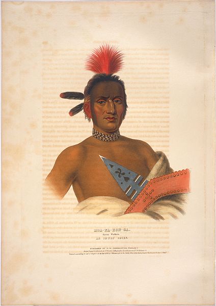
Moanahonga
Unknown. "Chief Moanahonga or Great Walker." 1842, University of Cincinnati Libraries Digital Collections, https://ids.si.edu/ids/deliveryService?id=SAAM-1985.66.153229_1.
Moanahonga is also known as “Great Walker” or “Big Neck”. He was a chief of an Ioway tribe. He is an important individual in the story “The Big Neck War,” which is a fight between incoming settlers in the Chariton River Valley and his tribe. This event is discussed in further detail on this website on the Town Myth page. To learn more about “The Big Neck War” as part of the Town Myth click here.
Ancestral Land
L'Isle, Guillaume de. "Carte de la Louisiane et du cours du Mississipi." 1718, Library of Congress Geography and Map Division, Washington, https://www.loc.gov/resource/g3700.ct000666/?r=0.448,0.246,0.372,0.329,0. [Image has been cropped].
Tribe Lands
While the Ioway tribe was initially a part of the Great Lakes region, they later moved south and west and had lands in several present day states. Their lands were in present day Wisconsin, Iowa, Minnesota, Missouri, Kansas, and Nebraska. For many years, the Ioway maintained a village in Council Bluffs, Iowa, but they eventually had to abandon the area due to aggression from the Lakota tribe. Additionally, members of the Ioway wished to move closer to French traders which aided in the decision to leave Council Bluffs (“History of the Ioway.”).
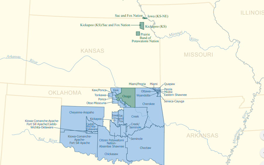
Today's Reservations
United States Census Bureau. "Americanindiansmapcensusbureau." 2006, Wikimedia Commons, https://commons.wikimedia.org/wiki/File:Americanindiansmapcensusbureau.gif. [Image has been cropped].
Current Tribal Lands
By 1838, the Ioway ceded their lands and were instead given territory along the Kansas and Nebraska border. Dissatisfied with this land, some of the tribe left and moved to a territory in Oklahoma. Today, the Ioway tribe has reservation land in both areas, but the two reservations and tribes are thought of as separate entities. The tribes are referred to as the Northern Iowa (or the Iowa Tribe of Kansas and Nebraska) and the Iowa Tribe of Oklahoma. The Northern Iowa have their headquarters in White Cloud, Kansas, while the Iowa Tribe of Oklahoma has their headquarters in Perkins, Oklahoma (“History of the Ioway.”).
To visit the Ioway tribe page click on the link below: